Download from: (TUN)Wadi Akarit_v20101015.kml
Download notes from: (TUN)Wadi Akatit_v20191015_notes.txt
Introduction
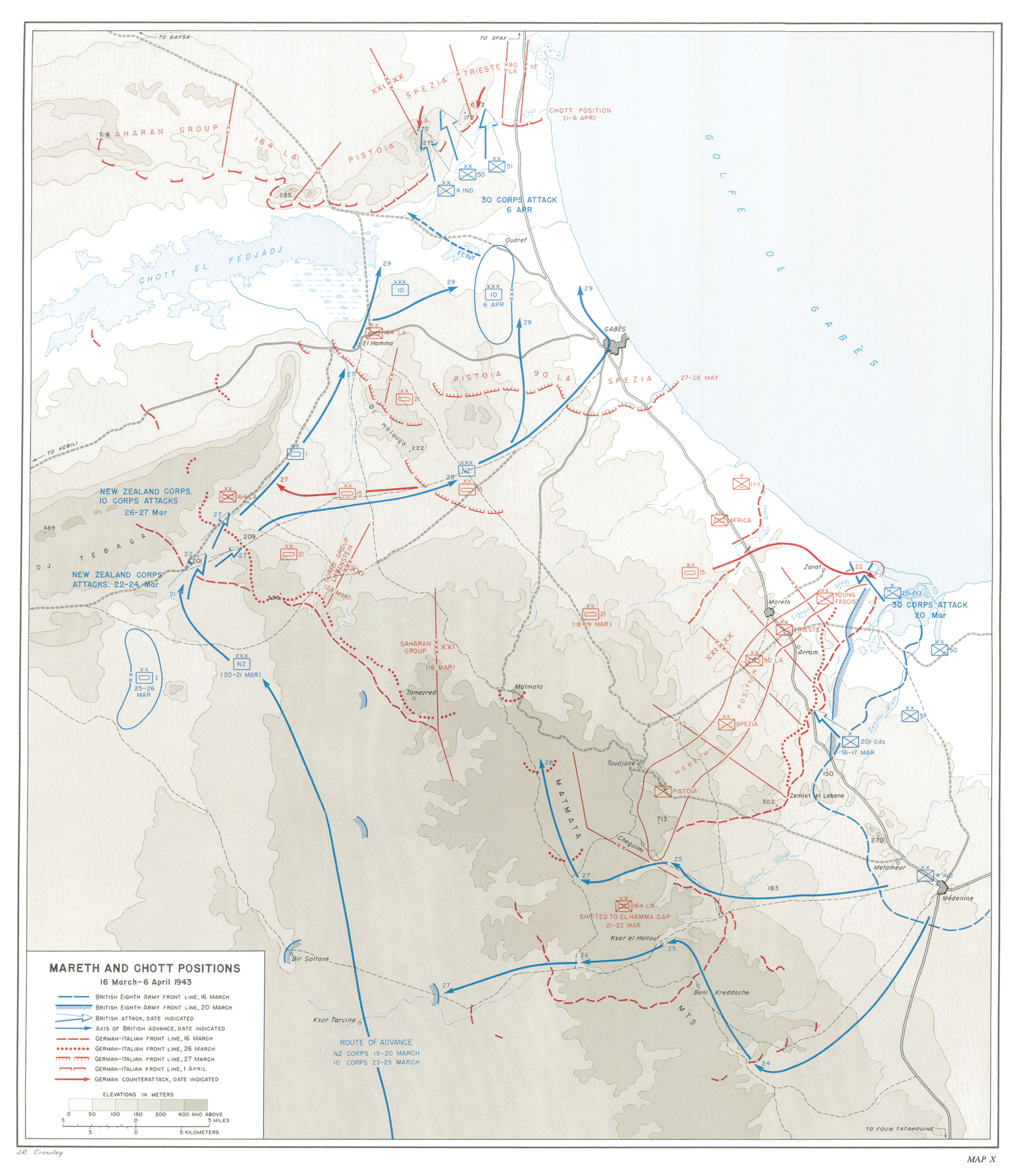
The Afrika Korps troops are withdrawing through Tunisia to the NW. The Eighth Army has overcome at the end of March 1943 the obstacle of the Mareth Line, a fortified line built by the French during the interwar period (Daillier, 1985), and contacts the troops arrived at El Hamma after the victory in the Tebaga Gap. They continue together to the north, taking Gabés on March 29th, and stopping at Oudref. In front of them, towards the north, rises a huge mountain chain that was poorly fortified by the Italians (Playfair & Molony, 1966: 362) and in Rommel's opinion, the only line of defense capable of stopping the Allies since the defeat at El Alamein.
The Wadi Akarit is a seasonal river that runs from the NW of Oudref to the NE, it flows into the Mediterranean after leaving on its left shore, at the crossing point of the coastal road to Tunis, the settling of Akarit. Just 500 m from the source of the Wadi Akarit, towards the W, the Wadi Telman is born. This is another seasonal stream that runs to the SW flowing into the Chott el Fededj (Sebkret el Hamma), part of a large endorheic basin that constitutes a huge saline swamp. Behind this line formed by the wadi and the chott, there is a mountain range formed by different djebels (from east to west: db. er Rummanah, dj. Tebaga Fatnasa, dj. Fetjedi es Srhir, dj. Haidoudi and dj. es Esmaia). This mountain range, with an NE-SW axis direction, takes height towards the W with a very abrupt relief. Playfair & Molony (1966: 362) offer a detailed description of the physical geography of Wadi Akarit and the djebels.
The defensive line formed by the combination of Wadi Akarit sector W and the djebel mountain ranges constitutes a relatively easy barrier to defend towards the south. The wadi Akarit is an important obstacle for the advance of armoured troops, since in its eastern sector it is very embedded, presenting almost vertical slopes up to 4 m high. Towards the W, one can find the Chott the Fededj, a huge swampy salt area that is insurmountable for any army along winter and early spring. Immediately below and to the north, the mountain line forms an almost continuous chain of about 200 km between the shore of the sea and the town of Tozeur. The eastern sector of this mountain range only presents a few steps suitable for armoured vehicles and tanks, which are thus easily defensible. Throughout this area of mountains and ravines, a defensive line formed by anti-tank ditches and minefields had been built buy italians, and Rommel would had to use to stop the Allied forces.
References
Daillier, P. 1985. Terre d´affrontements. Le Sud Tunisien. La Ligne Mareth et son étrange destin. Paris ,Nouvelles Editios latines, pp. 247.
Playfair, I.S.O. & Molony, C.J.C. 1966. History of the Second World War: The Mediterranean and Middle East IV. The destruction of the Axis forces in Africa. London, Her Majesty´s Stationery Office, pp. 556.
Other lectures
Barnes, B.S. 2007. Operation Scipio. The 8th Army at the Battle of the Wadi Akarit 6th April 1943, Tunisia. York, Sentinel Press, pp. 352.
Other maps
Howe, G.F. 1957. United States Army in World War II. Mediterranean Theater of Operations. Northwest Africa: Seizing the Initiative In the West. Wasihinton, D.C. Office of the Chief of Military History, Department of the Army. Mareth and Chott Positions, 16 March–6 April 1943
Stevens, W.G. 1962. Bardia to Enfidaville. Wellington, Historical Publications Branch. /30 corps' attack at wadi akarit, 5–6 april 1943/
Web. 51st Highland Division. Chapter: Battle of Wadi Akarit. April 1943
Web. Fighting through Dunkirk to Hamburg. A Green Howard´s Wartime Memoir. Wadi Akarit.
L. Medina
Thanks to Miguel and Elena for reviewing the translation